Key takeaways you will find in this article
- •With clear documentation and a holistic view of the organization, districts can enhance student and staff safety, reduce operating costs, and streamline maintenance processes more easily
- •Interactive Mapping empowers districts to optimize maintenance practices and efficiency
- •By providing a comprehensive visual overview of buildings, grounds, and emergency resources, districts can identify hazards, develop emergency response plans, and facilitate effective communication with first responders during crises
Table of contents
Transparency and traceability are essential for today’s school districts. Teachers, students, maintenance staff, administrators, and parents all benefit from a visual of their building.
School districts that have implemented a visual tool for managing their facilities see clear asset documentation, increased safety, better inventory management, and a holistic view of the organization.
This helps districts enhance student and staff safety, reduce operating costs, and streamline maintenance processes more easily.
That’s why FMX created its Interactive Mapping functionality to give users an easy-to-update and interactive guide to their assets.
What is Interactive Mapping?
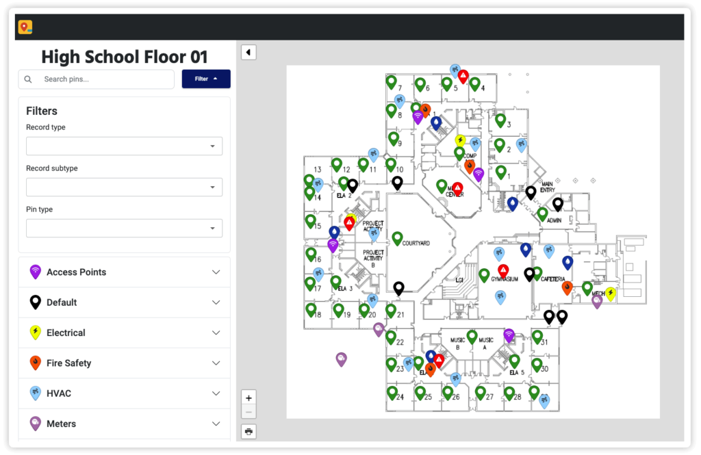
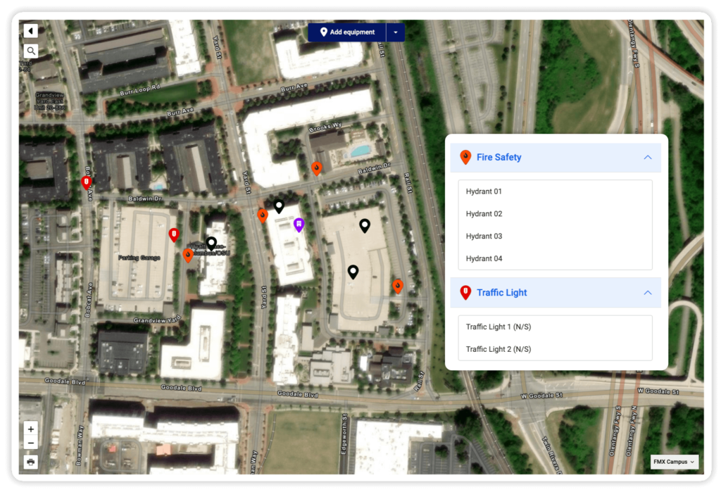
FMX’s Interactive Mapping feature is a lot like what it sounds like—an interactive map. Users leverage it to physically document equipment, inventory, resources, buildings, users, or other points of interest.
The tool gives users satellite, roadmap, and other map views of floor plans and shelving images to create a bird’s eye view of a district. Users can drag and drop pins to plot trackable assets and search and locate specific assets. They can filter, tag, and group maps to create curated views and move asset pins from location to location to track mobile equipment.
How do K-12 school districts benefit from Interactive Mapping?
School districts face mounting pressure to increase efficiency and district safety.
Moreover, operational efficiency is critical for reducing labor costs, ensuring facility life, and reducing emergency response times. Let’s explore how Interactive Mapping can help with each of these.

Improved maintenance practices and efficiency
Maintenance is a critical and seemingly unceasing part of a school district. And many school districts struggle with outdated maintenance processes or systems.
Good school maintenance uses routine and planned maintenance tasks to ensure the grounds, buildings, and all associated equipment are functional and safe. Having a visual representation and system of record enhances employees’ ability to complete these tasks.
Managers can dispatch the best-fit technician or worker to complete tasks exactly where and when they’re needed. And users don’t waste valuable labor hours searching for equipment or assets. They travel directly to their area and can scan a QR code so technicians can easily update work logs. This allows all stakeholders to track assignment completion and increase accountability.
Reduced capital expenditures on inventory and assets
Accurate inventory management is essential for controlling costs and maximizing resources in school districts. Interactive Mapping enables districts to maintain clear asset documentation, locate inventory faster, and identify areas for optimization.
By eliminating guesswork and reducing inventory searching times, Interactive Mapping helps districts minimize unnecessary expenditures. With real-time insights and data-driven decision-making, employees can track and locate resources more effectively, saving money in the process.
Fewer maintenance inefficiencies
Organizations lose up to $1.3 million a year due to maintenance inefficiency, according to a report by Formstack and Mantis Research. Maintenance staff will negatively impact the budget if they don’t know where tasks must be performed on assets.
Additionally, putting off maintenance due to a lack of transparency or operational inefficiency is costly. Research from the Pacific Partners Consulting Group found that every $1 in deferred maintenance costs $4 in capital renewal. Not getting to maintenance tasks because staff lacks the latest building management software can set an institution back.
Interactive Mapping enables maintenance staff to reduce task resolution speed, improve equipment documentation, help resource-strapped organizations become more efficient, prevent equipment failures, and mitigate costly delays. As a result, districts prevent unnecessary overhead expenditures and preserve critical budgets.
Organizations lose up to $1.3 million a year due to maintenance inefficiency.
Formstack and Mantis Research
Increased school district safety
Safety is a top priority for every school district, and Interactive Mapping is crucial in enhancing security. By providing a comprehensive visual overview of buildings, grounds, and emergency resources, Interactive Mapping enables districts to identify potential hazards, develop emergency response plans, and facilitate effective communication with first responders during crises.

School officials and first responders can use this information to perform emergency shut-offs or locate critical equipment during a crisis.
Additionally, Interactive Mapping allows employees to plot essential emergency resources on a map and regularly monitor preventive maintenance of the assets to ensure they work during an emergency.
Free K-12 PM Assessment Tool
Get personalized and actionable advice on how to improve your preventive maintenance practices.
A holistic district view
A map of district assets and resources is essential for strategic planning and decision-making. FMX’s feature offers K-12 districts a bird’s eye view of their entire organization, enabling leaders to gain insights into their assets.
By visualizing the entire district landscape, facility managers can identify opportunities for optimization, allocate resources more efficiently, and make informed decisions that support the district. With Interactive Mapping, districts can better understand their organization and unlock new opportunities for growth and success.
Why Interactive Mapping?
Interactive Mapping is critical for K-12 districts. School systems use FMX’s Interactive Mapping functionality as a pivotal solution for maintenance managers.
By providing a digital layout of districts, Interactive Mapping offers an effective solution for enhancing school safety, boosting maintenance efficiency, and reducing spend.
As school districts aim to improve maintenance practices and improve building safety, Interactive Mapping creates success for school districts.
Interested in seeing how FMX can transform your school system?
Discover the difference firsthand. Take the first step towards a more efficient, effective, and student-focused future.
Written by
Zach Jones
Content Manager at FMX